Walk date - July 24th 2016
Walk time - 2.59 hours
Distance - 7.43 miles
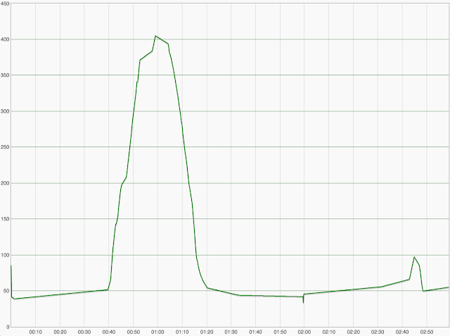
Accent - 420 feet
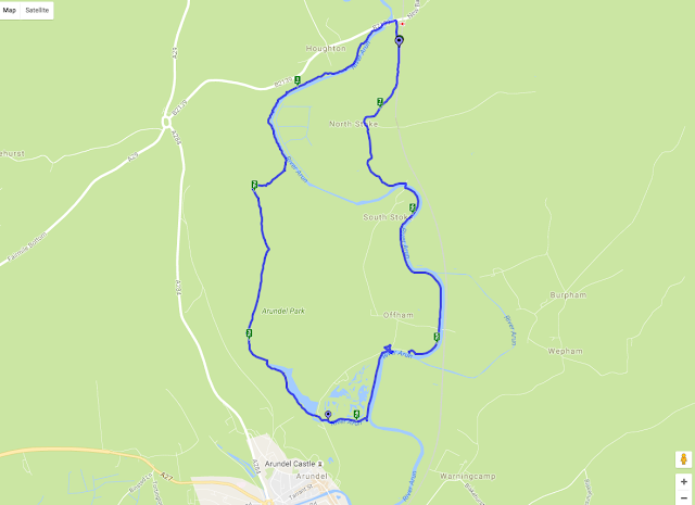
We parked in Amberly just down from the station, Amberley is on the B2139 which is off the A29 coming from Chichester of the A284 if you are heading up from Arundel, there is plenty of parking and a good supply of pubs and tea rooms plus a working museum.
We walked north from where we parked the car back to the B2139 across the 'pack horse' bridge taking the footpath south straight after the bridge picking up the west side of the river Arun, we started on a raised ridge or dyke running along the side of the river which soon dropped to a very boggy and flooded area, it looked like the raised walkways were being repaired at the time we walked through as there were planks laid on the ground and the stilts were being replaced, so the walking was hard work and very wet.
The path followed the river for around a mile and a half, apart from the short section of mud the walking was very good with nice views across the valley looking back towards the south downs, we passed a huge rope swing tied high up in a tree, this wasn't near a road or any village so I have no idea who made it or why, needless to say we had a swing!
The path followed the long distance route The Monarch's Way from here heading west away from the river and starting the only major incline on this walk
The path up this hill was very steep and on loose chalk which did make the route quite hard, this then opened out and picked on a farm track which although still steep was easier walking.
The views looking north towards Amberly and the south downs were worth the climb
We then followed the path across the top of Arundel Park and started a descent into the valley at the bottom we had two options, to take a path to the right which climbed a little and would bring us into the town of Arundel or take the path towards the mill pond and to the east side of the town and castle, we took the route towards the mill pond as we didn't plan to visit the town on this occasion.
Arundel park was quite busy with visitors wearing flip flops pushing push chairs and not following the marked paths, so we knew we were nearing a car park, we decided to take the path to the west side of the mill pond which was a lot less busy, the mill pond is large and on the opposite side had a hut to hire row boats.
We entered into a car park and if we took the right turn over the bridge we would have headed up into the town centre, we took the left turn along the south side of the wetlands park and followed a small tributary to the main river, after a short distance we came back onto the raised path along the west side of the river Arun, before we took the left turn to head north back towards Amberly we went a short way south so we could see the castle, after all we had walked this far!
Arundel castle is a proper English castle dating from the 11th century and modified over the next few hundred years, we haven't yet visited the castle but do plan to one day, it is quite spectacular to look at though and the view we had from the river Arun was worth the walk.
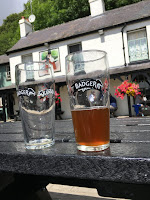
So we about turned and headed north along the west bank of the river Arun, the path was wide and easy to follow and after about half a mile joined the road at Offham and by the Black Rabbit pub, as it was just after midday we decided to stop here for lunch, however the menu was quite substantial and not something we wanted to take on board for the rest of the walk, later I found they did do a sandwich menu, although one was not available for us to easily find, we did take on a couple of pints of Badger's Furtsy Ferret, a nice light amber ale, we weren't really hungry so not a major loss but alas I can't review the food, the pub garden was along the river bank and was very popular for good reason
Walking on through the large car park for the pub we picked up the river path again and walked for a further mile and a half before crossing a bridge at South Stoke towards North Stoke now on the east side of the river. The footpath headed across a feild and past North Stoke Farm, where we picked up Stoke Road heading north, and about a mile back to the car.
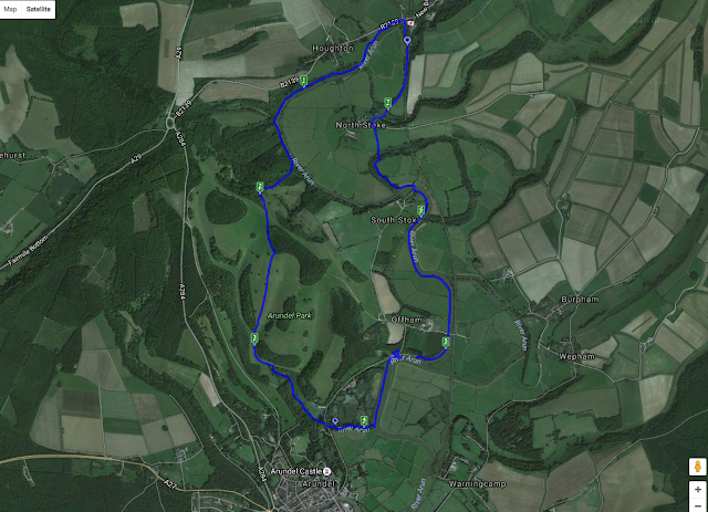
This was a really nice and relatively easy walk, the boggy path near the start was hard going but I am sure will be repaired very soon and the path above the bog on stilts replaced, the climb wasn't too high although the chalk soil was quite stoney, once we got onto the track it was much easier under foot, the descent was on a grass field and easy enough. We sprayed well with insect repellent which I think with the river and mill pond was essential, in the bottom of the valley it was quite humid and warm
Trip Advisor - The Black Rabbit
We didn't have a lunch on this occasion, but the Badger ale by Hall and Woodhouse was exceptionally nice and give us ample energy to carry on and the Black Rabbit pub was a very nice setting
Tales from walks and rambles plus routes for medium and short distance walks around Hampshire, Sussex and the South Downs Way
The Casual R'ambler
- The Casual 'R'ambler
- I am Simon, she is Liz and we have decided to spend our weekends (in the nice weather) walking, not super long distances, just little rambles to help keep us fit, spend some time together, enjoy the fantastic English countryside and eat some nice pub lunches @casual_Rambler
Wednesday, 27 July 2016
Thursday, 24 March 2016
Hambledon, blocked roads, paths and fields
Walk date - July 25th 2015
Walk time - 2.57 hours
Distance - 7.29 miles
Accent - 369 feet
The main road into Hambledon had been under major reconstruction for a very long time, and despite a sign saying road closed , I still drove along until stopped by the road works. So for this walk we didn't park in the car park of the pub we had selected for lunch, instead a little way out of the village
This was a good walk at over seven miles although wasn't too hard due to not being overly hilly, however it did provide plenty of issues for us along the way, armed with my OS map app we headed off the B2150 (main route in to Hambledon) and west on to Cams Hill which is a small track next to a tea room, a short way up Cams Hill you see a modern fence and gate across a gravel track on the right with a stile and a finger post marking the path, follow this track to the end where it joins another track on to which you turn left, follow this path around the edge of a field with a small woodland on your left hand side until you join up with the marked 'Wayfarer's Walk' path (green arrows with a WW inside them on finger posts, when the Wayfarer's Walk joins with 'Allan King Way' turn left on to the Allan King Way path until it comes to a road
I try to avoid road walking where possible although we did have a small amount at this stage, following Hambledon Lane as it bends first to the right then switches back left on the right you will see Broom Farm and shortly after this there is a footpath marked with a post on the left going straight over a field, this ends on another road called Armsworth Lane but heading straight along this road for a few meters takes you straight off again across more fields.
You can see from this picture the finger post taking us from Armsworth Lane heading straight across the field and it is towards that piece of woodland you can see, although the farmer hasn't left a clear path over the field, this is where a good OS map with rights of way indicated is invaluable
Anyway, we headed across the field and round the woodland onto a small and well kept farm, it's called Roy's Farm on the OS map, the pleasant surprise was the 'ha ha' which led along the path meaning my ankle height was at the horse's mouth height, it is nice not to have fences but also sometimes scary and potentially bity. Left out of Roy's Farm and on to Roy's Lane (not sure who this Roy is or was but he does seem to have a firm belief in his own self importance).
As Roy's Lane turns sharply to the left head straight on through a small woodland, or this was what we were planning, the path was so overgrown we had to backtrack to Roy's Lane and walk around the woodland (if you take a look at the map above you can see just after the 4 mile mark the aborted entry into the woodland) as it was the route round was on a decent farm track so no major issue, it just wasn't marked on my OS as a right of way!
Follow the marked path for about a mile until it comes out on to Hoe Street and directly opposite is Kelanne Stud, ideally take the track up to the stud farm and just before the gate there is a post marking the path to the right, this path heads around the farm, however as this picture shows the path was beyond impassable (yes the path is to the right of the fence!)
Again you can see at the 5 mile mark that we did try to make a way through but had to retreat. It is very frustrating when paths are not maintained as our walk is planned before hand from the OS map and to have so many unkept paths in one walk was a real shame and disappointment for us
We headed back turning right on to Hoe Street, past the stud farm fields on our right which were full of foals so it wasn't an unpleasant walk, just not planned, turning right onto a farm track we headed up hill on to Habens Lane turning off left towards a small wooded area known as Madam's Copse, the path followed this keeping the woods on the left and passing along the top side of several fields all separated with a stile and the obligatory group of cows
Thankfully the cows moved as we crossed the stile, but do take caution in a field of cows, they can be very dangerous
Eventually the field opened out and we could see the very large wooden bridge come stile that leads out of the field and back onto the B2150 where we started, just a short walk up the road to where the car was parked.
You will now see from the map we carried on past the car and into Hambledon village to find lunch
The Vine was a pleasant village pub and we headed for the garden, the menu was well priced for a village pub and the 'lighter bites' section was where we found the ploughman's ranging from £7 to £9, we ordered one each plus the obligatory pint and were happy with the portion size plus the fact it arrived on a plate
We were joined in the garden by a cycling stag party, one of their number being dressed in a skin tight pink body suit, which was nice, the food and drink bill came in at under £25
Trip Advisor - The Vine
Although we did suffer from blocked footpaths the walk was a decent length and walked in good time, there were no real climbs so nothing to raise too much of a sweat, not having much height menat no significant views, although we did enjoy some nice field walks once off the main long distance paths and farm tracks, and it always feels good for the soul to walk across a field full of crops, very English.
Wednesday, 24 February 2016
West Marden and the fields of West Sussex
Walk date - July 18th 2015
Walk time - 3 hours
Distance - 6.86 miles
Accent - 668 feet
Only a week after my major ankle injury and with a sturdy neoprene strap we ventured out again, brave I know but it's the way of the hardened casual rambler, the walk goes on whether we choose to stroll along or not, having said that I was considerably off my normal pace averaging 26 minutes a mile rather than my normal 20.
Our base was the Victoria Inn at West Marden only a few miles north from the previous weeks walk and still in West Sussex, the pub had a good sized car park we started off just before 11.30
Out of the pub car park and turning left along the road until we came to the B2146 diagonally opposite just off Locksash Lane on the right was a finger post into a field
You can see from the maps that we headed in pretty much a straight line through three fields, well marked and with a good path cut through the crops it was the best part of a mile before we came out again onto Locksash Lane which we turned right onto and followed all they way round until we hit the B2146 again. Now for those regular readers you will recall Locksash Lane and the B2146 from my last blog entry, yes this part of the walk is the same, we crossed the main road headed through the front garden again and then up the steep 'two walking pole' hill, once the top was reached we rested, rewarded ourselves with water but alas didn't get to see a baby deer this time.
We followed the same path as before for a short way and joined the farm track, however instead of heading straight on to Stansted Park we turn right just after Broadreed Farm and headed across more fields, this time following the line of some woodland to our left called Wythy Piece and Batty's Park
The path turned to the right away from the woodland and across another field heading towards the road leading back into the village, if you wanted to shorten this walk, turning right along this road now would have bought you back to the pub in about half a mile or so, we carried straight on though along a farm track and left along another farm track, again taking the right here would also have shortened the walk, my ankle was holding out so we headed on further.
A short way along the farm track we picked up a foot path running along the north edge of a couple of small fields with some woodland to our right, this then led out onto another farm track, we followed the track right past the farmhouse and around a small paddock behind up the hill and into quite an industrial farm called South Holt Farm. All the paths we follow although not major walkways are either public footpaths, bridleways or roads, all marked clearly on the Ordnance Survey maps, we have found these lesser used paths are still well maintained and signposted but very little used, we seldom pass another person whilst out walking along these tracks.
Turning right through South Holt Farm and onto the farm track which would now be our route back to West Marden, walking along the southern edge of Markwells Wood then across a field path dropping down to Horsely Farm and onto another farm track turning off after a short way left towards West Mardon Hall, the path drops as it follows the perimeter of the hall gardens before dropping us down onto the main road left through the village and back the our car.
The Victoria Inn was a good quality pub with a large garden, we ordered two ploughmans from the extensive lunch time menu with the option to add a £1 'handful' of chip, which needless to say I did, I was just hoping that they had good sized hands! each ploughmans was £9 plus the one extra £1 handful of chips so a little more than other pubs we had visited but the quality was absolutely fine, adding in a couple of beers took our bill to over £25 but not by much. It is worth noting that the Victoria Inn offers a 'walking group' menu for pre booked groups of 15 or more.
Trip Advisor - The Victoria Inn
This walk wasn't overly strenuous by design with mainly gentle hills to handle, with the exception of one steep climb which we were already familiar with, there were several 'pull out' points along the route so this could easily be shortened and made into a none cross country walk if you only wanted to stay on hard ground, however the main feature of this walk were the amazing fields, large and open with good paths through ripening crops, this truly was England's green and pleasant land!
Saturday, 13 February 2016
Walderton, Stansted Park and the biggest stile in the world
Walk date - July 11th 2015
Wak time - 2 hours 44 mins
Distance 7.3 miles
Accent - 624 feet
Our first walk outside of Hampshire took us to the village of Walderton within the South Downs national park just north of Chichester. We started at the village pub, the Barley Mow, which has a large cat park and is easy to find on the main road through Walderton.
This was a walk of two halves, the first being through fields on lesser used tracks and the second part being within the grounds of the Stansted Park estate
We left the pub car park and headed back along the village road, after a short walk we came to a side road turning right and then onto a foot path which followed the houses along the village edge, this path joined Cooks Lane and we turned right along the road for a few hundred yards before taking a path on the left, well marked with a finger post between two houses this brought us out into a large field.
After a mile of walking through well marked fields (with good paths cut through the crops) and crossing a couple of minor roads we came to a small woodland area, we cut through the corner of the coppice and dropped down to another field, a gentle climb led us to some really good views across the field we had just walked as we now turned back to head west. The path followed the southern edge of more wooded land along the top side of a field, a large bench was on the track, I couldn't see a plaque dedicating to anyone, but it did have a good view point.
The path joined onto a farm track, well made up and gravelled which in turn led onto a Locksash Lane, this dropped down to the B2146, which we needed to cross to pick up the next path.
The path went through the side of someone's front garden which was nice, and then a really, really steep climb, if you look at the gradient chart at the bottom of this section you can see at the 2.5 mile mark, it was a two stick climb, with a good lot of roots and stones to contend with, we rewarded ourselves at the top with water, and as I stood to refresh myself I looked along the track to see a baby deer staring back at me, soon joined by it's mother bounding over the track, collecting up its offspring and bouncing off into the heavily wooded land, we didn't see them again, but it is a nice reminder of what you get to see when walking, especially if you take the less used foot path rather than the main tracks.
As we came through this wooded area we joined another well made up farm track which we followed for about half a mile, at this point we had two options, I always like to build in a route to shorten the walk, and if we took the left hand path at this point it would cut out the Stansted Park section of the walk and about 2.5 miles, however the weather was excellent and we hoped that there maybe a wedding on at the big house and a couple of scraggy looking ramblers would add to the photo's
So right we did turn (I would later go on to regret that choice and not cut the walk short) and enter the Stansted Park estate, the track was a made up road so easy walking with open fields to our right and woodland on the left, the track followed the northern side of the big house before turning left and leading right in front, the path was fenced on both side so little opportunity for the masses to cause too much trouble
We then joined the main driveway into the house , garden centre and miniature railway which we followed for a short way until picking up another foot path at the end of the overflow car park.
The route took us through a couple of small fields before opening out onto a very large field with a good path cut right through on a diagonal running behind the big house, however getting onto this field did cause is some issues as we had to navigate the the biggest stile in the world, it is no secret that Mrs B isn't the tallest, but this fence crossing was something else even for me at well over 6 feet tall, the second step of which came up to Mrs B's hips!!
The walk across these fields was very pleasant, the crops now yellowing and getting ripe, a great view back across to Stansted House and again not another person using these well made and easy to access public rights of way. It must cost the farmers a lot to maintain these tracks and of course the loss of farming land, the upkeep of stiles etc, and I am sure they would be a lot happier if at least they were used, I'll come on to the paths that are not maintained in another blog
At the corner of a field we crossed a stile into a small stretch of gated road and my ruin.
We are at about the five and half mile mark, this small straight track is between two locked gates, and well protected although there is a stile to the side and a marked path, the track itself isn't made up so on grass, however the use of farm vehicles has left two deep ruts which thanks to the lush green grass are well covered, this led to all walkers worst fear (other than a bull in a field) the turned ankle!
My foot slipped from the center of the track into one of the deep rut, then only a few steps later the same happened again, I staggered to the end of the path seeking rest and refuge at the gate reaching out to grab support only to find the top of the gate was wrapped in barbed wire. It was at this point that my shortened walk option would have joined up and saved me a great deal of pain and cursing.
Needless to say the remainder of the walk was slow, although fortunately followed a made up road down quite a steep hill to rejoin the B246 and take us back to Walderton, still well over a mile but at least walkable, I was glad of my walking poles at this stage for sure.
The Barley Mow pub was very pleasant with a nice small garden which had a stream running along its edge, we ordered a couple of ciabattas and beer, again the bill was around the £20 mark, the food was good and came with chips to save me ordering a side, we both had cheese and onion, there isn't much to get wrong with that and the Barley Mow certainly got it right
Trip Advisor - The Barley Mow
This was a really good walk, at over 7 miles a good length and ideal for 2 to 3 hours, the terrain was good with a couple of climbs but nothing that couldn't be done with the aid of poles, so I turned my ankle and now do any distance walking with a support which isn't a bad precaution any way, it did put us out of walking for a couple of weeks though as my ankle did double in size for a few days!
Wak time - 2 hours 44 mins
Distance 7.3 miles
Accent - 624 feet
Our first walk outside of Hampshire took us to the village of Walderton within the South Downs national park just north of Chichester. We started at the village pub, the Barley Mow, which has a large cat park and is easy to find on the main road through Walderton.
This was a walk of two halves, the first being through fields on lesser used tracks and the second part being within the grounds of the Stansted Park estate
We left the pub car park and headed back along the village road, after a short walk we came to a side road turning right and then onto a foot path which followed the houses along the village edge, this path joined Cooks Lane and we turned right along the road for a few hundred yards before taking a path on the left, well marked with a finger post between two houses this brought us out into a large field.
After a mile of walking through well marked fields (with good paths cut through the crops) and crossing a couple of minor roads we came to a small woodland area, we cut through the corner of the coppice and dropped down to another field, a gentle climb led us to some really good views across the field we had just walked as we now turned back to head west. The path followed the southern edge of more wooded land along the top side of a field, a large bench was on the track, I couldn't see a plaque dedicating to anyone, but it did have a good view point.
The path joined onto a farm track, well made up and gravelled which in turn led onto a Locksash Lane, this dropped down to the B2146, which we needed to cross to pick up the next path.
The path went through the side of someone's front garden which was nice, and then a really, really steep climb, if you look at the gradient chart at the bottom of this section you can see at the 2.5 mile mark, it was a two stick climb, with a good lot of roots and stones to contend with, we rewarded ourselves at the top with water, and as I stood to refresh myself I looked along the track to see a baby deer staring back at me, soon joined by it's mother bounding over the track, collecting up its offspring and bouncing off into the heavily wooded land, we didn't see them again, but it is a nice reminder of what you get to see when walking, especially if you take the less used foot path rather than the main tracks.
As we came through this wooded area we joined another well made up farm track which we followed for about half a mile, at this point we had two options, I always like to build in a route to shorten the walk, and if we took the left hand path at this point it would cut out the Stansted Park section of the walk and about 2.5 miles, however the weather was excellent and we hoped that there maybe a wedding on at the big house and a couple of scraggy looking ramblers would add to the photo's
So right we did turn (I would later go on to regret that choice and not cut the walk short) and enter the Stansted Park estate, the track was a made up road so easy walking with open fields to our right and woodland on the left, the track followed the northern side of the big house before turning left and leading right in front, the path was fenced on both side so little opportunity for the masses to cause too much trouble
We then joined the main driveway into the house , garden centre and miniature railway which we followed for a short way until picking up another foot path at the end of the overflow car park.
The route took us through a couple of small fields before opening out onto a very large field with a good path cut right through on a diagonal running behind the big house, however getting onto this field did cause is some issues as we had to navigate the the biggest stile in the world, it is no secret that Mrs B isn't the tallest, but this fence crossing was something else even for me at well over 6 feet tall, the second step of which came up to Mrs B's hips!!
The walk across these fields was very pleasant, the crops now yellowing and getting ripe, a great view back across to Stansted House and again not another person using these well made and easy to access public rights of way. It must cost the farmers a lot to maintain these tracks and of course the loss of farming land, the upkeep of stiles etc, and I am sure they would be a lot happier if at least they were used, I'll come on to the paths that are not maintained in another blog
At the corner of a field we crossed a stile into a small stretch of gated road and my ruin.
We are at about the five and half mile mark, this small straight track is between two locked gates, and well protected although there is a stile to the side and a marked path, the track itself isn't made up so on grass, however the use of farm vehicles has left two deep ruts which thanks to the lush green grass are well covered, this led to all walkers worst fear (other than a bull in a field) the turned ankle!
My foot slipped from the center of the track into one of the deep rut, then only a few steps later the same happened again, I staggered to the end of the path seeking rest and refuge at the gate reaching out to grab support only to find the top of the gate was wrapped in barbed wire. It was at this point that my shortened walk option would have joined up and saved me a great deal of pain and cursing.
Needless to say the remainder of the walk was slow, although fortunately followed a made up road down quite a steep hill to rejoin the B246 and take us back to Walderton, still well over a mile but at least walkable, I was glad of my walking poles at this stage for sure.
The Barley Mow pub was very pleasant with a nice small garden which had a stream running along its edge, we ordered a couple of ciabattas and beer, again the bill was around the £20 mark, the food was good and came with chips to save me ordering a side, we both had cheese and onion, there isn't much to get wrong with that and the Barley Mow certainly got it right
Trip Advisor - The Barley Mow
This was a really good walk, at over 7 miles a good length and ideal for 2 to 3 hours, the terrain was good with a couple of climbs but nothing that couldn't be done with the aid of poles, so I turned my ankle and now do any distance walking with a support which isn't a bad precaution any way, it did put us out of walking for a couple of weeks though as my ankle did double in size for a few days!
Tuesday, 2 February 2016
Chalton and Hampshires oldest pub
Walk Date - July 5th 2015
Walk Time - 2 hours 5 mins
Distance - 5 miles
Ascent - 428 feet
Our youngest daughter joined us on this walk which started from the village car park, we normally try to kick a walk off around 10.30, we were a little later on this day not starting until just after noon and the car park was completely full, the village car park joins with the pub car park and after some driving around we did find a space. The Red Lion is a very popular pub not just for being Hampshire's oldest but also well positioned just off the A3 and signposted from the main road.
We left the pub and headed left across the road and followed South Lane up the hill, just after the road split we picked up a foot path through a field, well signed with a finger post, there was a steep descent (which had some steps cut into the hillside) down to a foot bridge over the main line railway (London to Portsmouth), we walked through a farm and crossed the road to follow a path which ran along the bottom edge of a row of fields, this turned into wood land as we started to head up hill through Ladyholt Park, a right turn off this track led to a drop down to a farm and then a turn back along the farm road.
A short way along the farm road we turned right onto a foot path across a field, again most of the field paths on this walk were well marked either around the field edge or in the case of those paths that cut across a field, clearly cut in by the farmer.
The path dropped onto a well made gravel track called Huckswood Lane on the OS map which is an ancient track believed to be Roman, this ended at a crossing with a road which we followed back across the railway line and then joined another path with a steep incline up the bank, at the top of this there was a field with a path clearly cut through, although on a slightly different line to my OS map.
This brought us out into the back of the church yard, which we walked through and came out opposite the Red Lion Pub.
We didn't eat a meal in the pub as it wasn't a meal eating time for most (it always is for me) so made do with a couple of nice cold beers and some gourmet crisps, The menu did look nice with good value snacks (sandwiches and jackets etc) from £7, we plan to walk this region again this year so will make a point to eat here
Trip Advisor - The Red Lion
This was a short walk at 5 miles and the only climbs were up and down to the railway everything else was gentle and easy to manage, our daughter at 17 didn't complain and enjoyed the fresh air, although did comment that this was about as far as she was prepared to walk in the name of 'fun'.
Friday, 29 January 2016
East Meon and Izaak Walton
Walk Date - July 4th 2015
Walk Time - 2 hours 19 mins
Distance - 6.59 miles
Ascent - 463 feet
"Good company in a journey makes the way seem shorter" Izaak Walton (author 1593-1683)
This was a walk we had planned the week before, Liz's brother was down for the day and it seemed like a plan, our youngest daughter was joining us as well, so in the words of Izaak Walton good company indeed, however after a mile the weather closed in and rain started, although not heavy and we did have water proofs, we walk for fun and this wasn't fun, so we returned to the car and aborted the walk
A week later and the weather was sunny and warm, an ideal start of the English summer, we parked in the pub car park of the Izaak Walton in East Meon, at around 10.30, I saw the landlord and asked if it was okay and we would be back in a few hours for lunch, I have found during these walks landlords are very accommodating to walkers (as long as you partake at some point) and if I can see someone I always let them know we'll be back
We walked out of the pub car park and turned left onto High Street, which we followed for just over a mile, a finger post at South Farm showed us the path to follow, through the farm itself (past some friendly lama's) we crossed a small bridge over the river Meon and followed a short track with a very lush wooded area to our right, in here is the source of the Meon.
The path was a gravel farm track with a slight incline as we headed up towards the South Downs Way, the tracked ended and we took a path through a field and the incline did get very steep at this point, although only a short walk, you can see from the altitude chart between mile 1.5 and 2.5.
Turning right picking up the well signed South Downs Way, which was now going to be our route for the next 3.5 miles, although after about a mile we came to the Droxford road and walked past the Sustainability Centre which had a cafe, we didn't stop so I can't comment on its services, shortly after this we crossed the road and picked up a very good track for the South Downs Way.
Turning right off the main track just before Hen Wood we headed onto a field path, some of these paths are better than others, this one was wide and well cut through the crops, remember though in this part of Hampshire there can be some quite large lumps of rock and chalk through these field paths, we followed the path round a collection of barns and picked up the farm road back to Coombe Road which we walked along back into East Meon village and the Izaak Walton for lunch.
The Izaak Walton is a friendly 'local's pub although they do cater for walkers and large groups, we ordered two Ploughmans and two pints plus the obligatory side of fries (for me) again all in at just over £20, as usual we headed into the garden because we were in our walking gear
The Ploughman's was served on a piece of lumber rather than a plate, but I let that slide as the food was excellent and plentiful, three large pieces of cheese, pickle and a pickled onion, warm bread, apple and salad complete the meal, the garden was very nice with ample seats.
Trip Advisor - The Izaak Walton
This was a good walk although the climb near the start was a sturdy one and it was very rewarding to have taken in a few miles of the South Downs Way, some wonderful views of the chalk downs of Hampshire with a filling ploughmans to finish off
Thursday, 28 January 2016
The Roebuck Wickham
Walk Date - June 27th 2015
Walk Time - 2 hours 33 mins
Distance - 7.32 miles
Ascent - 234 feet
We parked in the car park of the Roebuck Inn which is just over a mile north of Wickham in Hampshire on the A32, with it's distinctive giant wicker deer sitting in the garden, there are a few spaces directly in front of the pub and a large car park to the left with access to the garden.
We walked past the pub and took a small side road which took us over the old Meon Valley Railway line, don't miss the small path the leads between the houses, it is marked with a finger post and was a little over grown, this opened out into a small field, across the field we entered some woods with a foot bridge over the Meon river.
A short walk along the side of another field took us to a crossing of Newmans Hill and a finger post took us up a gentle incline of a graveled farm track, this turned sharply to the right and past a large factory or depot (which was closed but looked like it could be busy with large vehicles during the working day). Turning left onto Bishops Wood Road, we now had just over a mile of road walking, the road was quiet and passed some of Hampshire's more modern and grander houses bordering the golf course. At the end of the road we turned right onto Gravel Hill and the left in to Mislingford Road, only a short along the road we picked out the finger post on the left and back across fields again.
We only had a small amount of road walking as we joined Cott Street and soon turned off to follow the foot paths through more fields, fortunately all these paths were marked with fingers posts and were all clearly identifiable on my OS map (I have the OS map app on my phone which is invaluable) we past this beautiful cottage on Cott Street
The path took us from Cott Street through a very large orchard, we walked through two fields full of trees the first having the path head through the centre of the orchard and then following the edge of a field with a small wooded area to our right.
Heading through a large arable field we came to a hedge row with a very steep descent down to the main road, you can see the altitude chart just after the 4 mile mark, be careful as you leave through the hedge row directly onto the A32 with no side path or pavement and this is a very straight so fast section of the A32, fortunately the path you need is directly opposite and leads across the floodplain of the Meon valley.
Across a couple of footbridges and then some steps cut into the embankment of the old Meon Valley Railway line and we joined the footpath turning right and heading south for about 2 miles.
The railways track is a good path, this section mostly sheltered with tree's the first mile being along an embankment before dropping through a large wooded area and under the A32, we left the railway and headed up a path back on to the road we had originally started out from, the Roebuck is sign posted from the railway foot path.
The Roebuck is an old Victorian Inn, nice decor and very large, we ordered drinks and food and headed into the garden, we had the local cheese board sharing platter, it was served on a piece of slate - anyone who knows me will understand my views on eating off building materials rather than a plate - and I ordered a side of chips, the platter was £12.50, I can't recall how much the chips and beer cost, but in all around £20, the collection of cheese was good along with chutney, apple and celery plus some crackers, I was glad of the extra chips and would have preferred bread in place of the crackers.
Trip Advisor - The Roebuck Inn
As this was quite a gentle walk with no major climbs we are keeping it in the repertoire for visiting friends or relatives who would like a nice picturesque walk in the Hampshire countryside without expending too much energy and a high quality Inn at the end, there is some good field walking, an orchard, a chalk escarpment, the floodplain and river and finally the railway line with an old station (now converted into a house) along the route, Hampshire at its best!
Subscribe to:
Posts (Atom)