The Casual R'ambler

My photo
I am Simon, she is Liz and we have decided to spend our weekends (in the nice weather) walking, not super long distances, just little rambles to help keep us fit, spend some time together, enjoy the fantastic English countryside and eat some nice pub lunches @casual_Rambler

Thursday, 16 November 2017

Ale on tap.....

After a summer of some very good and busy events at the Hillbilly garden kitchen (see previous blog) I felt there was something missing. The question was how easy would it be to add a beer tap?

A lot of the craft ale bars that I have been to offer their cask and keg ales by the growler, this didn't really meet my need and whilst I could buy bottles of ale I still wanted a better solution

After a bit of research I found a really helpful chap (Neil) from Naked Keg, you can find him via his ebay shop (link here) or his web site (link here)

After much conversation we (Neil and myself) decided on a single tap with a 5 litre keg/growler and a sodastream CO2 bottle (more volume than CO2 mini bottles and easy to refill), this gives me the option to add a splitter to the gas bottle to add another tap and keg, but also be able to add more kegs to the single tap at busy events, I have now also added smaller 2 litre keg for every day use (I'm not a big drinker and I'd rather top up often than have beer get old)


I had a space on the bar top, I wanted to leave the larger area for food and decided to set the tap to one side, this gives me space for a second tap (although I might change the single tap tower to a double) and also a good area for other drinks and glasses etc. Rather than mount the drip tray on the counter top, I made a slot under the counter for it to slide in to, again gave me more bar space.


I added a shelf for the kegs which I would put inside a large bucket (to fill with ice) and mounted the CO2 bottle in a small piece of drain pipe (it works better if upright), this also made sure I could keep the beer line as short as possible (for efficiency)


Mounting the tap was simple, drilling a hole for the beer line and then securely bolting the tower to the bar top, the drip tray slides into the slot, the lines connect to the keg via a valve, a really nice unit that the beer line and gas line plug onto with a gas release valve (which can be used to vent gas before disconnecting or for purging the oxygen from the keg). The gas bottle has it's own regulator so you can manage the gas pressure (the keg is rated 60 psi although it works fine at around 15 psi)

And finally I need a good source of ale to keep the kegs topped up,  my new friends at Fallen Acorn Brewing (a five minute walk from home) provided that piece of the puzzle with their Expedition IPA, a slightly bitter citrus IPA and at 5.5% a reasonable strength


All in all a very nice set up and easy to implement, the advice from Neil at Naked Keg was invaluable and having a local brewery like Fallen Acorn nearby, an added bonus.


All the links are in the text in green, if you are thinking of something similar, I can recomend Naked Keg (for both equipment and advice)

Tuesday, 30 May 2017

Hillbilly garden kitchen

Something a little different than my normal blog about walks, our garden has been an evolving beast (as so many do when a young family grows up and the needs change), and in this new incarnation we have built a rustic garden kitchen, trying to capture a bit of the deep south and the home of the BBQ.

"Bulls Kitchen" in old Viking runic text (pyrography thanks to my daughter)

The area we had allocated was around 8ft square so easily big enough, it was at the end of the deck that we used for eating out on so a perfect fit


The first job (after clearing the land and leveling off was to mark out for the posts, I used 75mm fence posts set into the ground with post fix, i also used the same posts to make the frame and supports for the long food bar


Slabs were set (on a concrete base) just within the area of the kitchen that would be walked on, 10mm pea shingle (matching the rest of the garden) added all around


I really wanted 'used' galvanised roof sheets but wasn't able to find any suitable, or that I could transport and new galvanised cost too much. I had to settle with painted steel roof sheets, I'm sure they will weather in and not look too bad in a year or so


The walls were then clad in treated timber (the local wood yard cutting them pretty much to size and to fit in my car) this was painted first in colour outdoor wood paint before being 'aged' with brown watered down fence paint.


The effect is exactly what we wanted, looking like different old wood panels had been used, the front bar was added with a small counter top with space to sit at, the long counter is wider to allow for food to be served


The double barrel smoker fitted in along with the wood fired pizza oven, I built shelves for a drinks cabinet and loads of storage under the long food counter


and added in a fridge along with lighting (connected to an RCD switch in the garage)


The kitchen sits very nicely in the garden with the rest of the outdoor lighting


Then comes the fun task of adding the decoration, starting with the 'Jack Daniels' drinks shelf and empty 1 litre JD bottles with fairy lights inside


Aldi provided the galvanised food serving trays, napkin and cutlery holders plus the drink bottle stand


..... and finally the food, hot wings, jointed rabbit in garlic, lemon & herb marinade and mutton shish


The ever changing garden 16 years apart


I'll return with a walking blog soon (Petersfield to Rowlands Castle)

Thursday, 27 April 2017

The High Atlas and The Pasha of Marrakech's Kasbah

Walk date - April 11th 2017
Walk time - 2.33 hours
Distance - 6 miles
Altitude - 5,900 feet


.


We love Marrakech and this was our fourth visit to the city, on the second day we arranged (privately) for a trip into the High Atlas and for a walk, we left all the details up to our guide and good friend Charaf, giving him a free brief with the only request to have a walk in the mountains and visit a Kasbah.

Charaf picked us up at 7am from the main square in the heart of Marrakech (Jemaa el-Fna) in a really nice Dacia Duster, very comfortable and more than capable for the drive ahead, the plan was to take the N9 from Marrakech and then turn off once we have crested the High Atlas at the Tizi n'Tichka pass and aim to be in Telouet to visit the Kasbah and have a late lunch, stopping en-route for coffee and refreshments

We met the local guide a few miles outside Telouet, he was a Berber and descendant of the Glaoui tribe he grew up and still lives in Telouet, now working as a mountain guide in the High Atlas, his English was excellent and narration during the walk about the wildlife, villages, lifestyle and of course the history of the Glaoui tribe and the impact they had on the history of Morocco was truly fascinating.


We left the road and headed off towards a small Berber village, whilst the sky was a little over cast, it was still very hot and dry, the plain we were walking in although relatively flat was some 6,000 feet up in the mountains, the route mainly followed tracks although we did do a little light scrabbling over some looser ground.


The plan was to walk through a number of small villages with the Kasbah as our end point, Charaf drove on ahead and arranged lunch for us


This area of the High Atlas was one of a very few crossing points for the travelling caravans of traders coming from the Sahara and heading across to Marrakech and west of Morocco and of course Europe, they would stop at the Kasbah for safety, food and rest, then pay for guides through the mountains.

In one village we met a lady carrying a stack of freshly baked bread, she had the village bread oven and was taking the bread to her neighbours. As is the custom, should she meet anyone during her delivery she has to offer them bread, so we enjoyed some very freshly made bread, our guide had also brought with him some fruit for us during a brief rest period.

By most of the rivers near the villages the women were washing their floor mats and clothes


We past through an area where all the local villages used to gather for a weekly market, now used as a makeshift football pitch and headed back towards Telouet and the Kasbah


Let me just run through our equipment for the walk, we both had small trekking packs (mine a Helium 17l, Liz a Helium 10l) from Decathlon and both had 3 litre hydration packs (which we did need) make sure, if you do take on a trek like this (even a short one) to have plenty of water, it was hot and dry. We both had wide brimmed sun hats, mine a Peter Storm River Ranger from Millets, we had sturdy Karrimor boots and I was trying out my new Helikon-Tex Shorts, which were excellent and I can highly recommend, cool with plenty of free movement. We did carry jackets and waterproofs, just in case.


The final stop was the Kasbah, the tribal home and palace of El Glaoui, The Lord of the Atlas and Pasha of Marrakech who was heavily involved in the French occupation and coup in the early 20th century, shortly after his death in 1956 all his property was seized, including this Kasbah which was only returned to the local tribe in 2010, so for 60 years this magnificent palace was left untouched (except for the elements), only a small part is now open to the public and the £2 entrance fee seemed such a small amount compared to other more mainstream sights.


Due to the remoteness of the Kasbah, it isn't on the main tourist route (unlike Ait Benhaddou) we shared our visit with a handful of other people and having visited Ait Benhaddou before, I would say this was far better.


A small area of the Kasbah had a tiled roof which protected the inside, the decoration was just as it would have been when the Pasha still lived here. We spent quite a long time walking round the areas we were able to access with our guide, who used to play in the ruins as a child.


A short walk back to the main road and to a restaurant for a late lunch (it was about 3pm now and we had breakfast at 6.30 so much needed). Charaf had ordered for us and again didn't disappoint, we were first brought out a large tray of hot roasted vegetables and pasta with a basket of bread, followed by a lovely tagine of slow cooked lamb with roasted figs and apricots then a dessert of fresh fruit.


All this food plus water for less than £6 each

Then we got back into the car with Charaf and headed back to Marrakech stopping again en-route of a coffee (a very interesting tasting coffee at that)

If you ever feel the need to leave the hedonistic madness of Marrakech (why would you) but if you did, a trip to the mountains is highly recommended, you can book organised trips through most hotels or riads and travel with a small group. We are lucky to have our Moroccan friend in Charf we were able to arrange something a little more unique and a total mystery adventure as we left everything to Charaf to plan and arrange (if you would like Charaf's contact details, please let me know)

All I can say, is this was one of the most interesting and unique walks we have had the privilege to do in a country we love to visit, although I am sure more will follow......


We stayed at a small riad in Marrakech called Riad Maizie, managed by the wonderfully attentive Will and featured in the book Cinnamon City by the owner Miranda Innes


Wednesday, 27 July 2016

To Arundel Castle a Black Rabbit and a Fursty Ferret

Walk date - July 24th 2016
Walk time - 2.59 hours
Distance - 7.43 miles
Accent - 420 feet


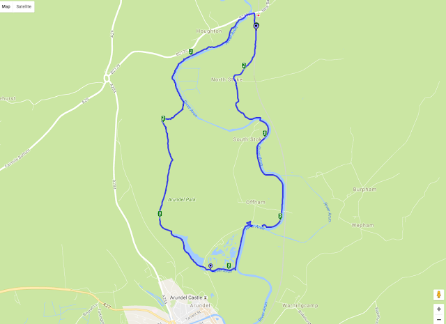
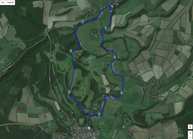
We parked in Amberly just down from the station, Amberley is on the B2139 which is off the A29 coming from Chichester of the A284 if you are heading up from Arundel, there is plenty of parking and a good supply of pubs and tea rooms plus a working museum.

We walked north from where we parked the car back to the B2139 across the 'pack horse' bridge taking the footpath south straight after the bridge picking up the west side of the river Arun, we started on a raised ridge or dyke running along the side of the river which soon dropped to a very boggy and flooded area, it looked like the raised walkways were being repaired at the time we walked through as there were planks laid on the ground and the stilts were being replaced, so the walking was hard work and very wet.

The path followed the river for around a mile and a half, apart from the short section of mud the walking was very good with nice views across the valley looking back towards the south downs, we passed a huge rope swing tied high up in a tree, this wasn't near a road or any village so I have no idea who made it or why, needless to say we had a swing!


The path followed the long distance route The Monarch's Way from here heading west away from the river and starting the only major incline on this walk

The path up this hill was very steep and on loose chalk which did make the route quite hard, this then opened out and picked on a farm track which although still steep was easier walking.


The views looking north towards Amberly and the south downs were worth the climb


We then followed the path across the top of Arundel Park and started a descent into the valley at the bottom we had two options, to take a path to the right which climbed a little and would bring us into the town of Arundel or take the path towards the mill pond and to the east side of the town and castle, we took the route towards the mill pond as we didn't plan to visit the town on this occasion.

Arundel park was quite busy with visitors wearing flip flops pushing push chairs and not following the marked paths, so we knew we were nearing a car park, we decided to take the path to the west side of the mill pond which was a lot less busy, the mill pond is large and on the opposite side had a hut to hire row boats.

We entered into a car park and if we took the right turn over the bridge we would have headed up into the town centre, we took the left turn along the south side of the wetlands park and followed a small tributary to the main river, after a short distance we came back onto the raised path along the west side of the river Arun, before we took the left turn to head north back towards Amberly we went a short way south so we could see the castle, after all we had walked this far!


Arundel castle is a proper English castle dating from the 11th century and modified over the next few hundred years, we haven't yet visited the castle but do plan to one day, it is quite spectacular to look at though and the view we had from the river Arun was worth the walk.

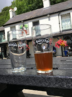
So we about turned and headed north along the west bank of the river Arun, the path was wide and easy to follow and after about half a mile joined the road at Offham and by the Black Rabbit pub, as it was just after midday we decided to stop here for lunch, however the menu was quite substantial and not something we wanted to take on board for the rest of the walk, later I found they did do a sandwich menu, although one was not available for us to easily find, we did take on a couple of pints of Badger's Furtsy Ferret, a nice light amber ale, we weren't really hungry so not a major loss but alas I can't review the food, the pub garden was along the river bank and was very popular for good reason

Walking on through the large car park for the pub we picked up the river path again and walked for a further mile and a half before crossing a bridge at South Stoke towards North Stoke now on the east side of the river. The footpath headed across a feild and past North Stoke Farm, where we picked up Stoke Road heading north, and about a mile back to the car.


This was a really nice and relatively easy walk, the boggy path near the start was hard going but I am sure will be repaired very soon and the path above the bog on stilts replaced, the climb wasn't too high although the chalk soil was quite stoney, once we got onto the track it was much easier under foot, the descent was on a grass field and easy enough. We sprayed well with insect repellent which I think with the river and mill pond was essential, in the bottom of the valley it was quite humid and warm

Trip Advisor - The Black Rabbit

We didn't have a lunch on this occasion, but the Badger ale by Hall and Woodhouse was exceptionally nice and give us ample energy to carry on and the Black Rabbit pub was a very nice setting


Thursday, 24 March 2016

Hambledon, blocked roads, paths and fields

Walk date - July 25th 2015
Walk time - 2.57 hours
Distance - 7.29 miles
Accent - 369 feet


The main road into Hambledon had been under major reconstruction for a very long time, and despite a sign saying road closed , I still drove along until stopped by the road works. So for this walk we didn't park in the car park of the pub we had selected for lunch, instead a little way out of the village

This was a good walk at over seven miles although wasn't too hard due to not being overly hilly, however it did provide plenty of issues for us along the way, armed with my OS map app we headed off the B2150 (main route in to Hambledon) and west on to Cams Hill which is a small track next to a tea room, a short way up Cams Hill you see a modern fence and gate across a gravel track on the right with a stile and a finger post marking the path, follow this track to the end where it joins another track on to which you turn left, follow this path around the edge of a field with a small woodland on your left hand side until you join up with the marked 'Wayfarer's Walk' path (green arrows with a WW inside them on finger posts, when the Wayfarer's Walk joins with 'Allan King Way' turn left on to the Allan King Way path until it comes to a road


I try to avoid road walking where possible although we did have a small amount at this stage, following Hambledon Lane as it bends first to the right then switches back left on the right you will see Broom Farm and shortly after this there is a footpath marked with a post on the left going straight over a field, this ends on another road called Armsworth Lane but heading straight along this road for a few meters takes you straight off again across more fields.

You can see from this picture the finger post taking us from Armsworth Lane heading straight across the field and it is towards that piece of woodland you can see, although the farmer hasn't left a clear path over the field, this is where a good OS map with rights of way indicated is invaluable

Anyway, we headed across the field and round the woodland onto a small and well kept farm, it's called Roy's Farm on the OS map, the pleasant surprise was the 'ha ha' which led along the path meaning my ankle height was at the horse's mouth height, it is nice not to have fences but also sometimes scary and potentially bity. Left out of Roy's Farm and on to Roy's Lane (not sure who this Roy is or was but he does seem to have a firm belief in his own self importance).

As Roy's Lane turns sharply to the left head straight on through a small woodland, or this was what we were planning, the path was so overgrown we had to backtrack to Roy's Lane and walk around the woodland (if you take a look at the map above you can see just after the 4 mile mark the aborted entry into the woodland) as it was the route round was on a decent farm track so no major issue, it just wasn't marked on my OS as a right of way!

Follow the marked path for about a mile until it comes out on to Hoe Street and directly opposite is Kelanne Stud, ideally take the track up to the stud farm and just before the gate there is a post marking the path to the right, this path heads around the farm, however as this picture shows the path was beyond impassable (yes the path is to the right of the fence!)

Again you can see at the 5 mile mark that we did try to make a way through but had to retreat. It is very frustrating when paths are not maintained as our walk is planned before hand from the OS map and to have so many unkept paths in one walk was a real shame and disappointment for us

We headed back turning right on to Hoe Street, past the stud farm fields on our right which were full of foals so it wasn't an unpleasant walk, just not planned, turning right onto a farm track we headed up hill on to Habens Lane turning off left towards a small wooded area known as Madam's Copse, the path followed this keeping the woods on the left and passing along the top side of several fields all separated with a stile and the obligatory group of cows


Thankfully the cows moved as we crossed the stile, but do take caution in a field of cows, they can be very dangerous

Eventually the field opened out and we could see the very large wooden bridge come stile that leads out of the field and back onto the B2150 where we started, just a short walk up the road to where the car was parked.

You will now see from the map we carried on past the car and into Hambledon village to find lunch


The Vine was a pleasant village pub and we headed for the garden, the menu was well priced for a village pub and the 'lighter bites' section was where we found the ploughman's ranging from £7 to £9, we ordered one each plus the obligatory pint and were happy with the portion size plus the fact it arrived on a plate

We were joined in the garden by a cycling stag party, one of their number being dressed in a skin tight pink body suit, which was nice, the food and drink bill came in at under £25


Trip Advisor - The Vine

Although we did suffer from blocked footpaths the walk was a decent length and walked in good time, there were no real climbs so nothing to raise too much of a sweat, not having much height menat no significant views, although we did enjoy some nice field walks once off the main long distance paths and farm tracks, and it always feels good for the soul to walk across a field full of crops, very English.